
Carte topographique Hohenstein-Ernstthal
Carte interactive
Cliquez sur la carte pour afficher l’altitude.
À propos de cette carte
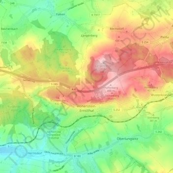
Nom : Carte topographique Hohenstein-Ernstthal, altitude, relief.
Lieu : Hohenstein-Ernstthal, Zwickau, Saxony, 09337, Germany (50.78858 12.65435 50.83392 12.76900)
Altitude moyenne : 369 m
Altitude minimum : 277 m
Altitude maximum : 482 m
Hohenstein-Ernsthal is located about 15 kilometres (9.3 mi) west of Chemnitz. The Ore Mountains rise south of the city. The highest point of Hohenstein-Ernstthal is the Pfaffenberg north of the town with an elevation of 479 metres (1,572 ft).
Autres cartes topographiques
Cliquez sur une carte pour visualiser sa topographie, son altitude et son relief.
Niederplanitz
Germany > Saxony > Zwickau > Zwickau
Niederplanitz, Zwickau-Süd, Zwickau, Langenweißbach, Zwickau, Saxony, 08134, Germany
Altitude moyenne : 316 m
Hartenstein
Hartenstein, Langenweißbach, Zwickau, Saxony, 08134, Germany
Altitude moyenne : 430 m
Wiesenburg
Germany > Saxony > Zwickau > Wildenfels
Wiesenburg, Wildenfels, Zwickau, Saxony, Germany
Altitude moyenne : 362 m
Crimmitschau
Crimmitschau, Crimmitschau-Dennheritz, Zwickau, Saxony, 08451, Germany
Altitude moyenne : 287 m