
Carte topographique Balikpapan
Carte interactive
Cliquez sur la carte pour afficher l’altitude.
À propos de cette carte
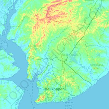
Nom : Carte topographique Balikpapan, altitude, relief.
Lieu : Balikpapan, East Kalimantan, Kalimantan, Indonesia (-1.28233 116.72880 -1.01330 117.02267)
Altitude moyenne : 21 m
Altitude minimum : -5 m
Altitude maximum : 129 m
Topography of Balikpapan is generally hilly (85%), with only small areas of flat land (15%), mostly along the coast and surrounding the hilly areas. The hills are less than 100 meters (330 feet) higher than the adjacent valleys. The altitude of Balikpapan ranges from 0 to 80 meters (260 feet) above sea level. The city proper itself is located on eastern side of Bay of Balikpapan.
Autres cartes topographiques
Cliquez sur une carte pour visualiser sa topographie, son altitude et son relief.
Kutai Timur
Kutai Timur, East Kalimantan, Kalimantan, Indonesia
Altitude moyenne : 226 m
Pulau Bilangbilangan
Pulau Bilangbilangan, East Kalimantan, Indonesia
Altitude moyenne : 133 m
Balikpapan
Indonesia > East Kalimantan > Balikpapan
Balikpapan, East Kalimantan, 76128, Indonesia
Altitude moyenne : 10 m