
Carte topographique Veitshöchheim
Carte interactive
Cliquez sur la carte pour afficher l’altitude.
À propos de cette carte
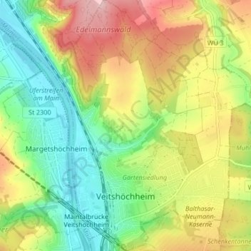
Nom : Carte topographique Veitshöchheim, altitude, relief.
Lieu : Veitshöchheim, Landkreis Würzburg, Bavaria, 97209, Germany (49.82018 9.86508 49.86265 9.92090)
Altitude moyenne : 247 m
Altitude minimum : 163 m
Altitude maximum : 360 m
Autres cartes topographiques
Cliquez sur une carte pour visualiser sa topographie, son altitude et son relief.
Prosselsheim
Germany > Bavaria > Landkreis Würzburg
Prosselsheim, Estenfeld (VGem), Landkreis Würzburg, Bavaria, 97279, Germany
Altitude moyenne : 276 m
Kist
Germany > Bavaria > Landkreis Würzburg
Kist, Verwaltungsgemeinschaft Kist, Landkreis Würzburg, Bavaria, 97270, Germany
Altitude moyenne : 346 m
Aub
Germany > Bavaria > Landkreis Würzburg
Aub, Verwaltungsgemeinschaft Aub, Landkreis Würzburg, Bavaria, 97239, Germany
Altitude moyenne : 317 m