
Faire un don
Équipez-vous pour votre prochaine aventure :
En tant que Partenaire Amazon, ce site perçoit une commission sur les achats éligibles sans surcoût pour vous.
Carte topographique Sandwick
Cliquez sur la carte pour afficher l’altitude.
Faire un don
Équipez-vous pour votre prochaine aventure :
En tant que Partenaire Amazon, ce site perçoit une commission sur les achats éligibles sans surcoût pour vous.
À propos de cette carte
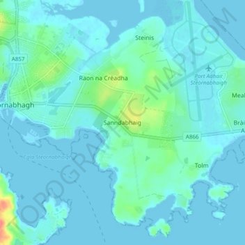
Nom : Carte topographique Sandwick, altitude, relief.
Lieu : Sandwick, Western Isles, Scotland, HS2 0AG, United Kingdom (58.18551 -6.37332 58.22551 -6.33332)
Altitude moyenne : 7 m
Altitude minimum : -1 m
Altitude maximum : 54 m
Faire un don
Équipez-vous pour votre prochaine aventure :
En tant que Partenaire Amazon, ce site perçoit une commission sur les achats éligibles sans surcoût pour vous.
Autres cartes topographiques
Cliquez sur une carte pour visualiser sa topographie, son altitude et son relief.
Barra
United Kingdom > Scotland > Western Isles > Brevig
The highest elevation on the island is Heaval, near the top of which is a prominent white marble statue of the Madonna and Child, called "Our Lady of the Sea", which was erected during the Marian year of 1954. The predominant faith on the island is Catholicism and the Catholic church dedicated to Our Lady of…
Altitude moyenne : 27 m
Faire un don
Équipez-vous pour votre prochaine aventure :
En tant que Partenaire Amazon, ce site perçoit une commission sur les achats éligibles sans surcoût pour vous.
South Uist
United Kingdom > Scotland > Western Isles
In the north west of the island at (57°20′N 07°20′W / 57.333°N 7.333°W / 57.333; -7.333), a missile testing range was built in 1957–58 to launch the Corporal missile, Britain and America's first guided nuclear weapon. This development went ahead despite significant protests, some locals…
Altitude moyenne : 15 m
Benbecula
United Kingdom > Scotland > Western Isles > Nunton
There is a dense cluster of lochs across almost the entire island, and almost the whole island is below 20 metres (70 feet) in elevation.
Altitude moyenne : 5 m
Faire un don
Équipez-vous pour votre prochaine aventure :
En tant que Partenaire Amazon, ce site perçoit une commission sur les achats éligibles sans surcoût pour vous.
North Rona
United Kingdom > Scotland > Western Isles
Rona (Scottish Gaelic: Rònaigh) is an uninhabited Scottish island in the North Atlantic. It is often referred to as North Rona to distinguish it from the island of South Rona in the Inner Hebrides. It has an area of 109 hectares (270 acres) and a maximum elevation of 108 metres (354 ft).
Altitude moyenne : 4 m
Faire un don
Équipez-vous pour votre prochaine aventure :
En tant que Partenaire Amazon, ce site perçoit une commission sur les achats éligibles sans surcoût pour vous.
Faire un don
Équipez-vous pour votre prochaine aventure :
En tant que Partenaire Amazon, ce site perçoit une commission sur les achats éligibles sans surcoût pour vous.
Faire un don
Équipez-vous pour votre prochaine aventure :
En tant que Partenaire Amazon, ce site perçoit une commission sur les achats éligibles sans surcoût pour vous.
Barra
United Kingdom > Scotland > Western Isles > Borve
The highest elevation on the island is Heaval, near the top of which is a prominent white marble statue of the Madonna and Child, called "Our Lady of the Sea", which was erected during the Marian year of 1954. The predominant faith on the island is Catholicism and the Catholic church dedicated to Our Lady of…
Altitude moyenne : 27 m
Faire un don
Équipez-vous pour votre prochaine aventure :
En tant que Partenaire Amazon, ce site perçoit une commission sur les achats éligibles sans surcoût pour vous.
Benbecula
United Kingdom > Scotland > Western Isles > Torlum
There is a dense cluster of lochs across almost the entire island, and almost the whole island is below 20 metres (70 feet) in elevation.
Altitude moyenne : 5 m
Faire un don
Équipez-vous pour votre prochaine aventure :
En tant que Partenaire Amazon, ce site perçoit une commission sur les achats éligibles sans surcoût pour vous.
Barra
United Kingdom > Scotland > Western Isles > Borve
The highest elevation on the island is Heaval, near the top of which is a prominent white marble statue of the Madonna and Child, called "Our Lady of the Sea", which was erected during the Marian year of 1954. The predominant faith on the island is Catholicism and the Catholic church dedicated to Our Lady of…
Altitude moyenne : 27 m
Benbecula
United Kingdom > Scotland > Western Isles > Nunton
There is a dense cluster of lochs across almost the entire island, and almost the whole island is below 20 metres (70 feet) in elevation.
Altitude moyenne : 5 m
Faire un don
Équipez-vous pour votre prochaine aventure :
En tant que Partenaire Amazon, ce site perçoit une commission sur les achats éligibles sans surcoût pour vous.