
Carte topographique Town of Lewiston
Carte interactive
Cliquez sur la carte pour afficher l’altitude.
À propos de cette carte
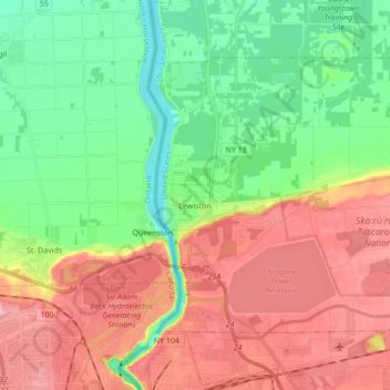
Nom : Carte topographique Town of Lewiston, altitude, relief.
Lieu : Town of Lewiston, Niagara County, New York, United States (43.13174 -79.05658 43.22037 -78.88476)
Altitude moyenne : 134 m
Altitude minimum : 70 m
Altitude maximum : 216 m
Autres cartes topographiques
Cliquez sur une carte pour visualiser sa topographie, son altitude et son relief.
Rapids
United States > New York > Niagara County
Rapids, Town of Lockport, Niagara County, New York, United States
Altitude moyenne : 179 m
Black Creek Village
United States > New York > Niagara County > City of Niagara Falls
Black Creek Village, City of Niagara Falls, Niagara County, New York, 14304, United States
Altitude moyenne : 176 m
Village of Lewiston
United States > New York > Niagara County > Town of Lewiston
Village of Lewiston, Town of Lewiston, Town of Niagara, Niagara County, New York, United States
Altitude moyenne : 122 m
City of Niagara Falls
United States > New York > Niagara County
City of Niagara Falls, Niagara County, New York, United States
Altitude moyenne : 180 m
Niagara Escarpment
United States > New York > Niagara County > City of Lockport
Niagara Escarpment, City of Lockport, Town of Lockport, Niagara County, New York, 14094, United States
Altitude moyenne : 165 m
Shooktown
United States > New York > Niagara County > City of Lockport
Shooktown, City of Lockport, Town of Lockport, Niagara County, New York, 14094, United States
Altitude moyenne : 191 m
Lewiston Heights
United States > New York > Niagara County > Town of Lewiston > Village of Lewiston
Lewiston Heights, Village of Lewiston, Town of Lewiston, Town of Niagara, Niagara County, New York, 14092, United States
Altitude moyenne : 144 m
City of Lockport
United States > New York > Niagara County
City of Lockport, Niagara County, New York, 14094, United States
Altitude moyenne : 174 m