
Faire un don
Équipez-vous pour votre prochaine aventure :
En tant que Partenaire Amazon, ce site perçoit une commission sur les achats éligibles sans surcoût pour vous.
Carte topographique Durango
Cliquez sur la carte pour afficher l’altitude.
Faire un don
Équipez-vous pour votre prochaine aventure :
En tant que Partenaire Amazon, ce site perçoit une commission sur les achats éligibles sans surcoût pour vous.
Durango
Durango (Spanish pronunciation: [duˈɾaŋɡo], Southeastern Tepehuan: Korian), is the capital and largest city of the northern Mexican state of Durango and the seat of the Durango municipality. It has a population of 654,876 as of the 2015 census. The city's official name is Victoria de Durango, Victoria having been added in honor of the first president of Mexico, Guadalupe Victoria, who hailed from the state of Durango. The city is located in the Valley of Guadiana and sits at an altitude of 1,890 m (6,201 ft).
Faire un don
Équipez-vous pour votre prochaine aventure :
En tant que Partenaire Amazon, ce site perçoit une commission sur les achats éligibles sans surcoût pour vous.
À propos de cette carte
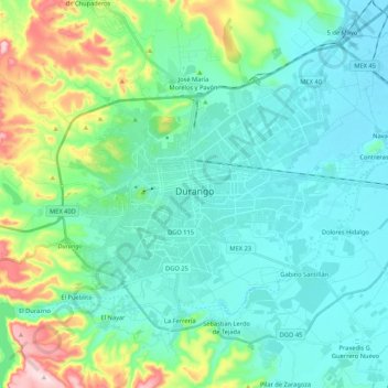
Nom : Carte topographique Durango, altitude, relief.
Lieu : Durango, Municipio de Durango, Durango, Mexico (23.94563 -104.73078 24.09514 -104.51793)
Altitude moyenne : 1 936 m
Altitude minimum : 1 860 m
Altitude maximum : 2 225 m
Faire un don
Équipez-vous pour votre prochaine aventure :
En tant que Partenaire Amazon, ce site perçoit une commission sur les achats éligibles sans surcoût pour vous.
Autres cartes topographiques
Cliquez sur une carte pour visualiser sa topographie, son altitude et son relief.