
Faire un don
Équipez-vous pour votre prochaine aventure :
En tant que Partenaire Amazon, ce site perçoit une commission sur les achats éligibles sans surcoût pour vous.
Carte topographique Schipkau
Cliquez sur la carte pour afficher l’altitude.
Faire un don
Équipez-vous pour votre prochaine aventure :
En tant que Partenaire Amazon, ce site perçoit une commission sur les achats éligibles sans surcoût pour vous.
Schipkau
On September 19th, 2024 construction work on GICON High-Altitude Wind Turbine in Klettwitz wind park, which belongs to Schipkau, started. It will have a nacelle height of 300 metres and a rotor diametre of 126 metres. When completed, it will not only be the tallest wind turbine in the world, but also the second-tallest man-made object in Germany and one of the tallest structures in the European Union [1].
Faire un don
Équipez-vous pour votre prochaine aventure :
En tant que Partenaire Amazon, ce site perçoit une commission sur les achats éligibles sans surcoût pour vous.
À propos de cette carte
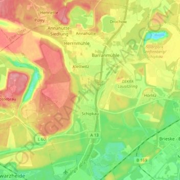
Nom : Carte topographique Schipkau, altitude, relief.
Altitude moyenne : 123 m
Altitude minimum : 79 m
Altitude maximum : 171 m
Faire un don
Équipez-vous pour votre prochaine aventure :
En tant que Partenaire Amazon, ce site perçoit une commission sur les achats éligibles sans surcoût pour vous.
Autres cartes topographiques
Cliquez sur une carte pour visualiser sa topographie, son altitude et son relief.