
Carte topographique Kosciusko County
Carte interactive
Cliquez sur la carte pour afficher l’altitude.
À propos de cette carte
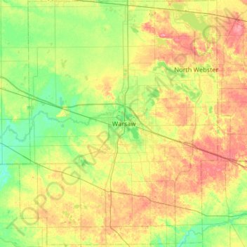
Nom : Carte topographique Kosciusko County, altitude, relief.
Lieu : Kosciusko County, Indiana, United States (41.03875 -86.07769 41.43692 -85.65179)
Altitude moyenne : 262 m
Altitude minimum : 233 m
Altitude maximum : 307 m
Autres cartes topographiques
Cliquez sur une carte pour visualiser sa topographie, son altitude et son relief.
Carlson Lake
United States > Indiana > Porter County > Valparaiso
Carlson Lake, Valparaiso, Porter County, Indiana, United States
Altitude moyenne : 250 m
Portage
United States > Indiana > Porter County
Portage, Porter County, Indiana, United States
Altitude moyenne : 190 m
Oriole Lake
United States > Indiana > Perry County
Oriole Lake, Perry County, Indiana, United States
Altitude moyenne : 211 m
French Lick
United States > Indiana > Orange County
French Lick, Orange County, Indiana, United States
Altitude moyenne : 186 m
Danes
United States > Indiana > Cass County
Danes, Cass County, Indiana, United States
Altitude moyenne : 203 m
Lawrence County
Lawrence County, Indiana, United States
Altitude moyenne : 203 m
Franklin
United States > Indiana > Johnson County
Franklin, Johnson County, Indiana, 46131, United States
Altitude moyenne : 230 m
Rockport
United States > Indiana > Spencer County
Rockport, Spencer County, Indiana, United States
Altitude moyenne : 121 m
Michigan City
United States > Indiana > LaPorte County
Michigan City, LaPorte County, Indiana, United States
Altitude moyenne : 188 m
Slough Creek
United States > Indiana > Jasper County
Slough Creek, Jasper County, Indiana, United States
Altitude moyenne : 206 m
Harrison County
Harrison County, Indiana, United States
Altitude moyenne : 205 m
Bloomington
United States > Indiana > Monroe County
Bloomington, Monroe County, Indiana, United States
Altitude moyenne : 241 m
Galveston
United States > Indiana > Cass County
Galveston, Cass County, Indiana, United States
Altitude moyenne : 246 m
Griffith
United States > Indiana > Lake County
Griffith, Lake County, Indiana, 46319, United States
Altitude moyenne : 190 m
Madison
United States > Indiana > Madison
Madison, Jefferson County, Indiana, 47250, United States
Altitude moyenne : 227 m
Fish Creek
United States > Indiana > LaPorte County > Fish Lake
Fish Creek, Fish Lake, LaPorte County, Indiana, United States
Altitude moyenne : 217 m
Jeffersonville
United States > Indiana > Clark County
Jeffersonville, Clark County, Indiana, 47130, United States
Altitude moyenne : 150 m
Ripley County
United States > Indiana > Ripley County
Ripley County, Indiana, United States
Altitude moyenne : 279 m
Brownsburg
United States > Indiana > Hendricks County
Brownsburg, Hendricks County, Indiana, 46112, United States
Altitude moyenne : 271 m
Merrillville
United States > Indiana > Lake County > Merrillville
Merrillville, Lake County, Indiana, 46410, United States
Altitude moyenne : 204 m
Fort Wayne
United States > Indiana > Allen County
Fort Wayne, Allen County, Indiana, United States
Altitude moyenne : 246 m
Sullivan
United States > Indiana > Sullivan County > Sullivan > Sullivan
Sullivan, Sullivan County, Indiana, 47882, United States
Altitude moyenne : 153 m
Grafton
United States > Indiana > Posey County
Grafton, Posey County, Indiana, United States
Altitude moyenne : 120 m
Alert
United States > Indiana > Decatur County > Alert
Alert, Decatur County, Indiana, 47236, United States
Altitude moyenne : 232 m
Muncie
United States > Indiana > Delaware County
Muncie, Delaware County, Indiana, United States
Altitude moyenne : 291 m
Carmel
United States > Indiana > Hamilton County > Carmel
Carmel, Hamilton County, Indiana, United States
Altitude moyenne : 253 m
Morningside
United States > Indiana > Delaware County > Muncie > Morningside
Morningside, Muncie, Delaware County, Indiana, 47303, United States
Altitude moyenne : 291 m
Taggart
United States > Indiana > Brown County > Taggart
Taggart, Brown County, Indiana, United States
Altitude moyenne : 237 m
West Lafayette
United States > Indiana > Tippecanoe County
West Lafayette, Tippecanoe County, Indiana, United States
Altitude moyenne : 192 m
Terrace Bay
United States > Indiana > Carroll County > Terrace Bay
Terrace Bay, Carroll County, Indiana, United States
Altitude moyenne : 205 m
Indianapolis
United States > Indiana > Indianapolis
Indianapolis, Marion County, Indiana, 46204, United States
Altitude moyenne : 241 m
Gary
United States > Indiana > Lake County > Gary
Gary, Lake County, Indiana, 46402, United States
Altitude moyenne : 187 m
Glen Eden
United States > Indiana > Steuben County > Glen Eden
Glen Eden, Steuben County, Indiana, 46703, United States
Altitude moyenne : 310 m
Mill Race
United States > Indiana > Lawrence County > Spring Mill Village
Mill Race, Spring Mill Village, Lawrence County, Indiana, 47446, United States
Altitude moyenne : 199 m
Dunn
United States > Indiana > Benton County > Dunn
Dunn, Benton County, Indiana, United States
Altitude moyenne : 240 m
Mackey
United States > Indiana > Gibson County
Mackey, Gibson County, Indiana, United States
Altitude moyenne : 131 m
Greenfield
United States > Indiana > Greenfield
Greenfield, Hancock County, Indiana, United States
Altitude moyenne : 272 m
Indianapolis
United States > Indiana > Marion County
Indianapolis, Marion County, Indiana, United States
Altitude moyenne : 241 m
Terre Haute
United States > Indiana > Terre Haute
Terre Haute, Vigo County, Indiana, United States
Altitude moyenne : 159 m
Westchester
United States > Indiana > Fort Wayne > Westchester
Westchester, Fort Wayne, Allen County, Indiana, 48606, United States
Altitude moyenne : 242 m
Crows Nest
United States > Indiana > Crows Nest
Crows Nest, Indiana, United States
Altitude moyenne : 229 m
Fish Lake
United States > Indiana > Fish Lake
Fish Lake, LaPorte County, Indiana, 46365, United States
Altitude moyenne : 215 m