
Carte topographique Río Grande
Carte interactive
Cliquez sur la carte pour afficher l’altitude.
À propos de cette carte
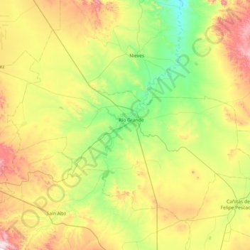
Nom : Carte topographique Río Grande, altitude, relief.
Lieu : Río Grande, Zacatecas, 98400, Mexico (23.55942 -103.39197 24.06550 -102.67373)
Altitude moyenne : 2 059 m
Altitude minimum : 1 748 m
Altitude maximum : 2 663 m
Over 96% of the municipality's area lies in the drainage basin of the Aguanaval River, the main watercourse in the area which flows south to north through the municipality. This river was known as the Río Grande in the 16th and 17th centuries despite its modest size. The highest point in the municipality is the Cerro Tetilla Grande located at 23°41′N 102°51′W / 23.683°N 102.850°W / 23.683; -102.850 with an elevation of 2,370 metres (7,780 ft) above sea level.
Autres cartes topographiques
Cliquez sur une carte pour visualiser sa topographie, son altitude et son relief.
Pozo Hondo
Mexico > Zacatecas > Villa de Cos
Pozo Hondo, Villa de Cos, Zacatecas, Mexico
Altitude moyenne : 2 032 m