
Carte topographique Sky Valley
Carte interactive
Cliquez sur la carte pour afficher l’altitude.
À propos de cette carte
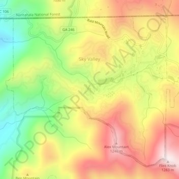
Nom : Carte topographique Sky Valley, altitude, relief.
Lieu : Sky Valley, Rabun County, Georgia, 30537, United States (34.96659 -83.35311 34.99589 -83.31062)
Altitude moyenne : 973 m
Altitude minimum : 652 m
Altitude maximum : 1 275 m
According to the United States Census Bureau, the city has a total area of 3.0 square miles (7.8 km2), all land. The elevation of the valley floor is approximately 3100 feet above sea level, while areas within the city limits on the slopes of Rabun Bald exceed 4200 feet. Sky Valley is Georgia's highest incorporated city and one of the highest municipalities in the eastern United States.
Autres cartes topographiques
Cliquez sur une carte pour visualiser sa topographie, son altitude et son relief.
Dillard
United States > Georgia > Rabun County
Dillard, Rabun County, Georgia, United States
Altitude moyenne : 691 m
Tiger
United States > Georgia > Rabun County
Tiger, Rabun County, Georgia, United States
Altitude moyenne : 608 m
Clayton
United States > Georgia > Rabun County > Clayton
Clayton, Rabun County, Georgia, 30525, United States
Altitude moyenne : 634 m
Black Rock Mountain State Park
United States > Georgia > Rabun County
Black Rock Mountain State Park, Rabun County, Georgia, 30525, United States
Altitude moyenne : 869 m