
Faire un don
Équipez-vous pour votre prochaine aventure :
En tant que Partenaire Amazon, ce site perçoit une commission sur les achats éligibles sans surcoût pour vous.
Carte topographique Kohala
Cliquez sur la carte pour afficher l’altitude.
Faire un don
Équipez-vous pour votre prochaine aventure :
En tant que Partenaire Amazon, ce site perçoit une commission sur les achats éligibles sans surcoût pour vous.
Kohala
In Kohala, the numerous dikes near the summit inhibit groundwater from seeping downslope to the northeast, where it naturally wants to go. Rather, the Kohala dike complex guides it northwest or southeast, down the axis of the rift zones, just like the surface water. On the other hand, the three smaller valleys between the large ones - Honopue, Honokea, and Honokane Iki - as well as the many smaller gulches which are not yet valleys, are deprived of groundwater by the orientation of the rift zone and its dikes. Without the large amount of water that is received by the bigger valleys, these valleys grow far more slowly. Due to its topography as essentially a flat crater floor surrounded by cones and fault scarps, the main caldera is affected relatively little by erosion from water.
Faire un don
Équipez-vous pour votre prochaine aventure :
En tant que Partenaire Amazon, ce site perçoit une commission sur les achats éligibles sans surcoût pour vous.
À propos de cette carte
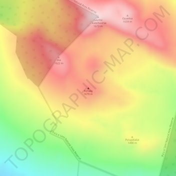
Nom : Carte topographique Kohala, altitude, relief.
Lieu : Kohala, Hawaiʻi County, Hawaii, United States (20.07494 -155.71874 20.07504 -155.71864)
Altitude moyenne : 1 489 m
Altitude minimum : 1 233 m
Altitude maximum : 1 665 m
Faire un don
Équipez-vous pour votre prochaine aventure :
En tant que Partenaire Amazon, ce site perçoit une commission sur les achats éligibles sans surcoût pour vous.
Autres cartes topographiques
Cliquez sur une carte pour visualiser sa topographie, son altitude et son relief.
Faire un don
Équipez-vous pour votre prochaine aventure :
En tant que Partenaire Amazon, ce site perçoit une commission sur les achats éligibles sans surcoût pour vous.
Kukuihaele CDP
United States > Hawaii > Hawaiʻi County
Kukuihaele is located on the north side of the island of Hawaii at 20°7′10″N 155°34′16″W / 20.11944°N 155.57111°W / 20.11944; -155.57111 (20.119536, -155.571160). It sits at an elevation of 730 feet (220 m) atop cliffs overlooking Waipio Bay. Hawaii Route 240 passes through the southern…
Altitude moyenne : 173 m
Faire un don
Équipez-vous pour votre prochaine aventure :
En tant que Partenaire Amazon, ce site perçoit une commission sur les achats éligibles sans surcoût pour vous.
Faire un don
Équipez-vous pour votre prochaine aventure :
En tant que Partenaire Amazon, ce site perçoit une commission sur les achats éligibles sans surcoût pour vous.
Faire un don
Équipez-vous pour votre prochaine aventure :
En tant que Partenaire Amazon, ce site perçoit une commission sur les achats éligibles sans surcoût pour vous.
Faire un don
Équipez-vous pour votre prochaine aventure :
En tant que Partenaire Amazon, ce site perçoit une commission sur les achats éligibles sans surcoût pour vous.