
Faire un don
Équipez-vous pour votre prochaine aventure :
En tant que Partenaire Amazon, ce site perçoit une commission sur les achats éligibles sans surcoût pour vous.
Carte topographique Burkes Pass
Cliquez sur la carte pour afficher l’altitude.
Faire un don
Équipez-vous pour votre prochaine aventure :
En tant que Partenaire Amazon, ce site perçoit une commission sur les achats éligibles sans surcoût pour vous.
Burkes Pass
Burkes Pass is a mountain pass and at its base, a small town on State Highway 8 at the entrance to the Mackenzie Country in South Canterbury, New Zealand. It is named after Michael John Burke (1812 Co. Galway-1869 Ballarat), a graduate of Trinity College Dublin, who drove a team of bullocks through the passageway which leads up into the Mackenzie Country in 1855. This was an alternative route to the Mackenzie Pass, which the notorious alleged sheep stealer, James Mckenzie, had used to take his sheep into the Otago goldfields. Burkes Pass separates the Two Thumb Range to the north from the Rollesby and Albury ranges to the south, and sits at an altitude of 709 metres (2,326 ft). A memorial to Burke stands close to the pass's saddle.
Faire un don
Équipez-vous pour votre prochaine aventure :
En tant que Partenaire Amazon, ce site perçoit une commission sur les achats éligibles sans surcoût pour vous.
À propos de cette carte
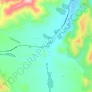
Nom : Carte topographique Burkes Pass, altitude, relief.
Lieu : Burkes Pass, Mackenzie District, Canterbury, New Zealand (-44.10944 170.63279 -44.06944 170.67279)
Altitude moyenne : 622 m
Altitude minimum : 510 m
Altitude maximum : 916 m
Faire un don
Équipez-vous pour votre prochaine aventure :
En tant que Partenaire Amazon, ce site perçoit une commission sur les achats éligibles sans surcoût pour vous.
Autres cartes topographiques
Cliquez sur une carte pour visualiser sa topographie, son altitude et son relief.