
Carte topographique Cut Bank
Carte interactive
Cliquez sur la carte pour afficher l’altitude.
À propos de cette carte
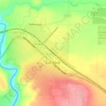
Nom : Carte topographique Cut Bank, altitude, relief.
Lieu : Cut Bank, Glacier County, Montana, United States (48.62381 -112.34579 48.64705 -112.31473)
Altitude moyenne : 1 147 m
Altitude minimum : 1 083 m
Altitude maximum : 1 198 m
Cut Bank experiences a semi-arid climate (Köppen BSk) with long, cold, dry winters and short, warm, wetter summers. In winter, bitterly cold arctic air masses move south and impact the eastern side of the American Continental Divide. During such invasions Cut Bank, with its comparatively high elevation and topography is frequently the coldest location in the lower 48 U.S. States. Being close to the eastern slopes of the Rocky Mountains also makes the area subject to occasional Chinook winds that can rapidly increase the local temperature.
Autres cartes topographiques
Cliquez sur une carte pour visualiser sa topographie, son altitude et son relief.
Pray Lake
United States > Montana > Glacier County
Pray Lake, Glacier County, Montana, United States
Altitude moyenne : 1 717 m
Basin Mountain
United States > Montana > Glacier County
Basin Mountain, Glacier County, Montana, United States
Altitude moyenne : 2 075 m