
Carte topographique Westminster
Carte interactive
Cliquez sur la carte pour afficher l’altitude.
À propos de cette carte
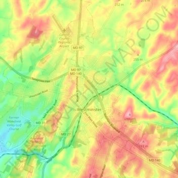
Nom : Carte topographique Westminster, altitude, relief.
Lieu : Westminster, Carroll County, Maryland, United States (39.54647 -77.04708 39.62053 -76.95920)
Altitude moyenne : 228 m
Altitude minimum : 161 m
Altitude maximum : 290 m
Westminster lies in the humid subtropical climate zone bordering on a humid continental climate, with hot and humid summers and cool winters with highly variable seasonal snowfall. Due to its elevation, distance from the Chesapeake Bay and urban heat island, temperatures in Westminster are often considerably lower than in Baltimore, especially at night.
Autres cartes topographiques
Cliquez sur une carte pour visualiser sa topographie, son altitude et son relief.
Gist
United States > Maryland > Carroll County
Gist, Carroll County, Maryland, United States
Altitude moyenne : 203 m
Kimberly Heights
United States > Maryland > Carroll County
Kimberly Heights, Carroll County, Maryland, United States
Altitude moyenne : 209 m
Mount Airy
United States > Maryland > Carroll County
Mount Airy, Carroll County, Maryland, 21771, United States
Altitude moyenne : 221 m
Union Bridge
United States > Maryland > Carroll County
Union Bridge, Carroll County, Maryland, United States
Altitude moyenne : 138 m
Sykesville
United States > Maryland > Carroll County
Sykesville, Carroll County, Maryland, United States
Altitude moyenne : 152 m