
Carte topographique Frisco Peak
Carte interactive
Cliquez sur la carte pour afficher l’altitude.
À propos de cette carte
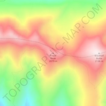
Nom : Carte topographique Frisco Peak, altitude, relief.
Lieu : Frisco Peak, Idaho County, Idaho, United States of America (46.20848 -115.10767 46.20858 -115.10757)
Altitude moyenne : 1 863 m
Altitude minimum : 1 532 m
Altitude maximum : 2 131 m
Autres cartes topographiques
Cliquez sur une carte pour visualiser sa topographie, son altitude et son relief.
Cormorant Island
United States of America > Idaho
Cormorant Island, Caribou County, Idaho, United States of America
Altitude moyenne : 1 955 m
Lake Fork
United States of America > Idaho > Lake Fork
Lake Fork, Valley County, Idaho, 83630, United States of America
Altitude moyenne : 1 512 m
Driggs
United States of America > Idaho > Driggs
Driggs, Teton County, Idaho, United States of America
Altitude moyenne : 1 866 m
Blackfoot
United States of America > Idaho > Blackfoot
Blackfoot, Bingham County, Idaho, United States of America
Altitude moyenne : 1 371 m