
Carte topographique South-West Oxford
Carte interactive
Cliquez sur la carte pour afficher l’altitude.
À propos de cette carte
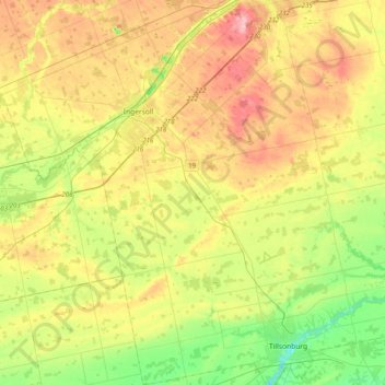
Nom : Carte topographique South-West Oxford, altitude, relief.
Altitude moyenne : 281 m
Altitude minimum : 201 m
Altitude maximum : 388 m
In its wilderness state, the former Dereham township had thousands of acres of swamp and marsh land which limited its use for agriculture. Several large drainage projects brought great improvement and remain as essential parts of the township's farmland infrastructure. The township topography still has several large forested areas which are remnants of the original swamps on which drainage system runoff is concentrated.
Autres cartes topographiques
Cliquez sur une carte pour visualiser sa topographie, son altitude et son relief.
Sweaburg
Canada > Ontario > Oxford County > South-West Oxford
Sweaburg, South-West Oxford, Oxford County, Ontario, N0J 1A0, Canada
Altitude moyenne : 317 m
Mount Elgin
Canada > Ontario > Oxford County > South-West Oxford
Mount Elgin, South-West Oxford, Oxford County, Ontario, N0J 1N0, Canada
Altitude moyenne : 281 m
Salford
Canada > Ontario > Oxford County > South-West Oxford
Salford, South-West Oxford, Oxford County, Southwestern Ontario, Ontario, N5C 3J8, Canada
Altitude moyenne : 291 m
Beachville
Canada > Ontario > Oxford County > South-West Oxford
Beachville, South-West Oxford, Oxford County, Southwestern Ontario, Ontario, N5C 3K1, Canada
Altitude moyenne : 303 m