
Carte topographique New Britain
Carte interactive
Cliquez sur la carte pour afficher l’altitude.
À propos de cette carte
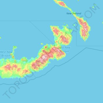
Nom : Carte topographique New Britain, altitude, relief.
Altitude moyenne : 77 m
Altitude minimum : 0 m
Altitude maximum : 2 268 m
The island is part of two ecoregions. The New Britain-New Ireland lowland rain forests extend from sea level to 1000 meters elevation. The New Britain-New Ireland montane rain forests cover the mountains of New Britain above 1000 meters elevation.
Autres cartes topographiques
Cliquez sur une carte pour visualiser sa topographie, son altitude et son relief.
Pandi
Papua New Guinea > East New Britain
Pandi, Pomio District, East New Britain, Islands Region, Papua New Guinea
Altitude moyenne : 277 m