
Carte topographique South Kingstown
Carte interactive
Cliquez sur la carte pour afficher l’altitude.
À propos de cette carte
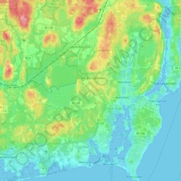
Nom : Carte topographique South Kingstown, altitude, relief.
Lieu : South Kingstown, South County, Rhode Island, United States (41.36111 -71.62457 41.52529 -71.44690)
Altitude moyenne : 30 m
Altitude minimum : -5 m
Altitude maximum : 114 m
Autres cartes topographiques
Cliquez sur une carte pour visualiser sa topographie, son altitude et son relief.
Sandy Point
United States > Rhode Island > South County > Westerly
Sandy Point, Westerly, South County, Rhode Island, United States
Altitude moyenne : 1 m
Richmond
United States > Rhode Island > South County
Richmond, South County, Rhode Island, United States
Altitude moyenne : 56 m
North Kingstown
United States > Rhode Island > South County
North Kingstown, South County, Rhode Island, United States
Altitude moyenne : 35 m
Kenyon
United States > Rhode Island > South County > Richmond > Kenyon
Kenyon, Richmond, South County, Rhode Island, 02836, United States
Altitude moyenne : 41 m
West Kingston
United States > Rhode Island > South County > South Kingstown > West Kingston
West Kingston, South Kingstown, South County, Rhode Island, 02881, United States
Altitude moyenne : 41 m
Cummock Island
United States > Rhode Island > South County > South Kingstown
Cummock Island, South Kingstown, South County, Rhode Island, United States
Altitude moyenne : 9 m
Narragansett
United States > Rhode Island > South County
Narragansett, South County, Rhode Island, 02882, United States
Altitude moyenne : 12 m