
Carte topographique General Sibley Park & Campground
Carte interactive
Cliquez sur la carte pour afficher l’altitude.
À propos de cette carte
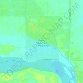
Nom : Carte topographique General Sibley Park & Campground, altitude, relief.
Altitude moyenne : 498 m
Altitude minimum : 492 m
Altitude maximum : 506 m
Autres cartes topographiques
Cliquez sur une carte pour visualiser sa topographie, son altitude et son relief.
Lake Sakakawea
Lake Sakakawea, McLean County, North Dakota, USA
Altitude moyenne : 651 m
Theodore Roosevelt National Park
Theodore Roosevelt National Park, Billings County, North Dakota, USA
Altitude moyenne : 684 m
Rock Lake
USA > North Dakota > Rock Lake
Rock Lake, Towner County, North Dakota, USA
Altitude moyenne : 472 m
Lake Ashtabula
Lake Ashtabula, 15th Street Southeast, Barnes County, North Dakota, 58056, USA
Altitude moyenne : 423 m
Lake Tschida
Lake Tschida, 56th Street Southwest, Grant County, North Dakota, USA
Altitude moyenne : 661 m
Sheyenne River
Sheyenne River, Nelson County, North Dakota, 58361, USA
Altitude moyenne : 428 m
Lake Metigoshe State Park
Lake Metigoshe State Park, Bottineau County, North Dakota, USA
Altitude moyenne : 660 m
Boundary Lake
Boundary Lake, 23rd Avenue Northeast, Bottineau County, North Dakota, USA
Altitude moyenne : 685 m
Dunseith
USA > North Dakota > Dunseith
Dunseith, Rolette County, North Dakota, USA
Altitude moyenne : 521 m