
Carte topographique Awakeri
Carte interactive
Cliquez sur la carte pour afficher l’altitude.
À propos de cette carte
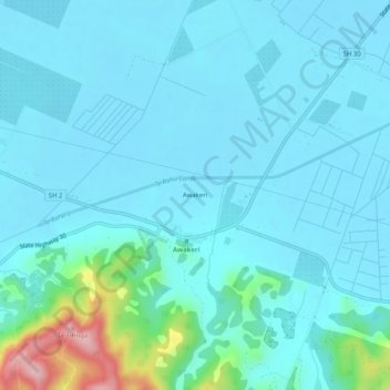
Nom : Carte topographique Awakeri, altitude, relief.
Altitude moyenne : 31 m
Altitude minimum : 3 m
Altitude maximum : 216 m
Autres cartes topographiques
Cliquez sur une carte pour visualiser sa topographie, son altitude et son relief.
Lake Otumahi
New Zealand > Bay of Plenty > Awakeri
Lake Otumahi, State Highway 30, Awakeri, Whakatane District, Bay of Plenty, 3192, New Zealand
Altitude moyenne : 40 m