
Carte topographique Dinagat Islands
Carte interactive
Cliquez sur la carte pour afficher l’altitude.
À propos de cette carte
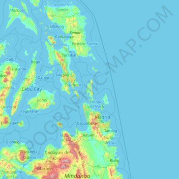
Nom : Carte topographique Dinagat Islands, altitude, relief.
Lieu : Dinagat Islands, Caraga, Philippines (7.59779 123.02518 12.71779 128.14518)
Altitude moyenne : 91 m
Altitude minimum : -2 m
Altitude maximum : 2 797 m
Dinagat Islands is a young island-province at the northern tip of Mindanao. Many describe Dinagat Islands as a hidden gem of the Caraga Region XIII. The Islands are enriched with great bio-diversity, abundant natural wonders and rich resources. Dinagat Islands has a multitude of fascinating white sandy beaches with arrays of colossal rock formations. These sites and attractions are as diverse as the topography of the islands and islets.
Autres cartes topographiques
Cliquez sur une carte pour visualiser sa topographie, son altitude et son relief.
Dinagat Island
Dinagat Island, Dinagat Islands, Caraga, Philippines
Altitude moyenne : 29 m
Dinagat Islands
Dinagat Islands, Caraga, Philippines
Altitude moyenne : 24 m