
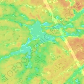
Carte topographique Island Lake
Carte interactive
Cliquez sur la carte pour afficher l’altitude.
À propos de cette carte
Nom : Carte topographique Island Lake, altitude, relief.
Altitude moyenne : 223 m
Altitude minimum : 203 m
Altitude maximum : 237 m
Autres cartes topographiques
Cliquez sur une carte pour visualiser sa topographie, son altitude et son relief.
Ellsmere Island
Canada > Ontario > Parry Sound District > The Archipelago Township
Ellsmere Island, The Archipelago Township, Parry Sound District, Central Ontario, Ontario, Canada
Altitude moyenne : 197 m
Novar
Canada > Ontario > Parry Sound District > Perry Township
Novar, Perry Township, Parry Sound District, Central Ontario, Ontario, P0A 1R0, Canada
Altitude moyenne : 348 m
Doe Lake
Canada > Ontario > Parry Sound District > Ryerson Township
Doe Lake, Ryerson Township, Parry Sound District, Central Ontario, Ontario, Canada
Altitude moyenne : 311 m
McKellar
Canada > Ontario > Parry Sound District > McKellar Township
McKellar, McKellar Township, Parry Sound District, Central Ontario, Ontario, P0G 1C0, Canada
Altitude moyenne : 250 m
Carson Bay
Canada > Ontario > Parry Sound District > The Archipelago Township
Carson Bay, The Archipelago Township, Parry Sound District, Central Ontario, Ontario, Canada
Altitude moyenne : 187 m
Seguin Township
Canada > Ontario > Parry Sound District
Seguin Township, Parry Sound District, Central Ontario, Ontario, Canada
Altitude moyenne : 247 m
Parry Sound
Canada > Ontario > Parry Sound District > Parry Sound
Parry Sound, Parry Sound District, Central Ontario, Ontario, P2A 1B2, Canada
Altitude moyenne : 202 m
Emsdale
Canada > Ontario > Parry Sound District > Perry Township > Emsdale
Emsdale, Perry Township, Parry Sound District, Central Ontario, Ontario, P0A 1J0, Canada
Altitude moyenne : 349 m
Whitestone
Canada > Ontario > Parry Sound District
Whitestone, Parry Sound District, Central Ontario, Ontario, P0A 1G0, Canada
Altitude moyenne : 249 m