
Carte topographique Danvers
Carte interactive
Cliquez sur la carte pour afficher l’altitude.
À propos de cette carte
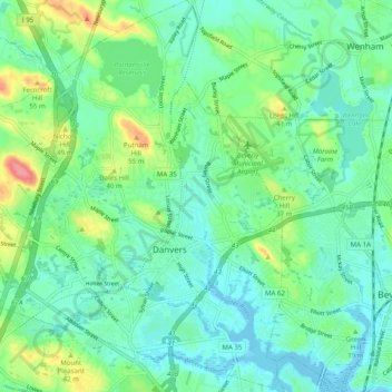
Nom : Carte topographique Danvers, altitude, relief.
Lieu : Danvers, Essex County, Massachusetts, United States (42.54016 -71.00281 42.61324 -70.90762)
Altitude moyenne : 22 m
Altitude minimum : -2 m
Altitude maximum : 81 m
Though being at sea level in the Danversport area, the town has numerous hills reaching around 130 to 180 feet in elevation, including Dales Hill (located at St. John's Preparatory School), Ferncroft Hill, Folly Hill, Hathorne Hill, Lindall Hill, Nichols Hill, Putnam Hill, Rocky Hill and Whipple Hill (part of Endicott Park).