
Carte topographique Sukoharjo
Carte interactive
Cliquez sur la carte pour afficher l’altitude.
À propos de cette carte
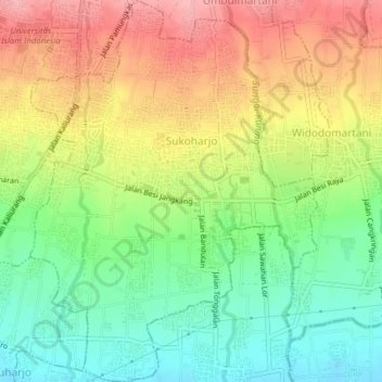
Nom : Carte topographique Sukoharjo, altitude, relief.
Altitude moyenne : 280 m
Altitude minimum : 222 m
Altitude maximum : 347 m
Autres cartes topographiques
Cliquez sur une carte pour visualiser sa topographie, son altitude et son relief.
Sidoagung
Indonésie > Daerah Istimewa Yogyakarta > Sleman
Sidoagung, Godean, Sleman, Daerah Istimewa Yogyakarta, Jawa, Indonésie
Altitude moyenne : 120 m
Sukoharjo
Indonésie > Daerah Istimewa Yogyakarta > Sleman > Sukoharjo
Sukoharjo, Sleman, Daerah Istimewa Yogyakarta, 55584, Indonésie
Altitude moyenne : 296 m