
Carte topographique Epperstone CP
Carte interactive
Cliquez sur la carte pour afficher l’altitude.
À propos de cette carte
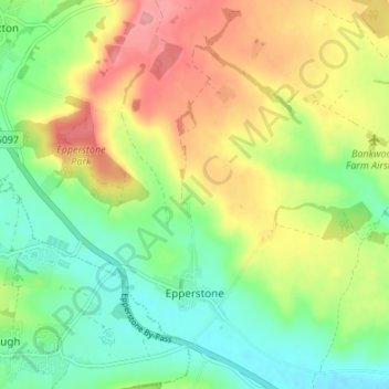
Nom : Carte topographique Epperstone CP, altitude, relief.
Altitude moyenne : 69 m
Altitude minimum : 25 m
Altitude maximum : 129 m
The report notes Epperstone's "very distinctive character... a combination of topography, buildings, trees and walls.... The constantly changing views make it an attractive space to move through." It also notes, "The approach to the village from the west is along a tunnel formed by overhanging trees, including ash, holly, maple, horse chestnut and yew. This creates a strong sense of arrival as you enter the village." The report criticises additions made to the former police training centre in Main Street.[18]
Autres cartes topographiques
Cliquez sur une carte pour visualiser sa topographie, son altitude et son relief.
Halam CP
United Kingdom > England > Nottinghamshire > Newark and Sherwood
Halam CP, Newark and Sherwood, Nottinghamshire, England, United Kingdom
Altitude moyenne : 57 m
East Stoke CP
United Kingdom > England > Nottinghamshire > Newark and Sherwood
East Stoke CP, Newark and Sherwood, Nottinghamshire, England, United Kingdom
Altitude moyenne : 24 m