
Carte topographique Deutsch Kaltenbrunn
Carte interactive
Cliquez sur la carte pour afficher l’altitude.
À propos de cette carte
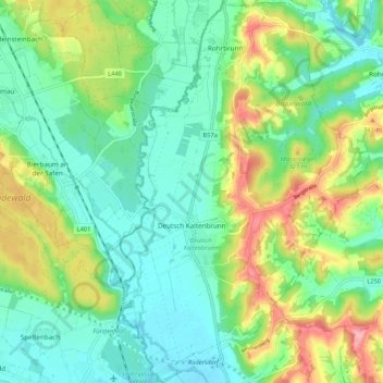
Nom : Carte topographique Deutsch Kaltenbrunn, altitude, relief.
Altitude moyenne : 288 m
Altitude minimum : 246 m
Altitude maximum : 376 m
Autres cartes topographiques
Cliquez sur une carte pour visualiser sa topographie, son altitude et son relief.
Rax
Österreich > Burgenland > Bezirk Jennersdorf > Jennersdorf > Rax
Rax, Jennersdorf, Bezirk Jennersdorf, Burgenland, 8380, Österreich
Altitude moyenne : 260 m