
Carte topographique Chugchillan
Carte interactive
Cliquez sur la carte pour afficher l’altitude.
À propos de cette carte
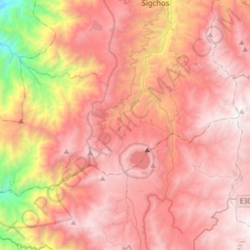
Nom : Carte topographique Chugchillan, altitude, relief.
Lieu : Chugchillan, Sigchos, Cotopaxi, 00000, Ecuador (-0.89499 -79.11735 -0.75441 -78.87170)
Altitude moyenne : 3 158 m
Altitude minimum : 1 188 m
Altitude maximum : 4 280 m
Autres cartes topographiques
Cliquez sur une carte pour visualiser sa topographie, son altitude et son relief.
Quilotoa
Ecuador > Cotopaxi > Sigchos > Chugchillan
Quilotoa, Chugchillan, Sigchos, Cotopaxi, 050456, Ecuador
Altitude moyenne : 3 553 m
Laguna Quilotoa
Ecuador > Cotopaxi > Sigchos > Chugchillan
Laguna Quilotoa, Chugchillan, Sigchos, Cotopaxi, Ecuador
Altitude moyenne : 3 636 m