
Faire un don
Équipez-vous pour votre prochaine aventure :
En tant que Partenaire Amazon, ce site perçoit une commission sur les achats éligibles sans surcoût pour vous.
Carte topographique Nedumpana
Cliquez sur la carte pour afficher l’altitude.
Faire un don
Équipez-vous pour votre prochaine aventure :
En tant que Partenaire Amazon, ce site perçoit une commission sur les achats éligibles sans surcoût pour vous.
Nedumpana
Nedumpana is a countryside in Kollam district featuring a typical kerala village consisting paddy fields, wetlands, river channels and highlands. The area can be categorised into Ida Nadu (Mid land or plains) with an average elevation of 108 meter above mean sea level. Laterite soil and Alluvial Soil constitutes the major soil types. Major rainy season is the South West Monsoon, which bring about 130cm of rain. Out of the total area , 6276 acres of land is culturable.
Faire un don
Équipez-vous pour votre prochaine aventure :
En tant que Partenaire Amazon, ce site perçoit une commission sur les achats éligibles sans surcoût pour vous.
À propos de cette carte
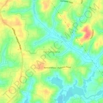
Nom : Carte topographique Nedumpana, altitude, relief.
Lieu : Nedumpana, Kollam, Kerala, 691580, India (8.88875 76.67450 8.92875 76.71450)
Altitude moyenne : 26 m
Altitude minimum : 1 m
Altitude maximum : 60 m
Faire un don
Équipez-vous pour votre prochaine aventure :
En tant que Partenaire Amazon, ce site perçoit une commission sur les achats éligibles sans surcoût pour vous.