
Faire un don
Équipez-vous pour votre prochaine aventure :
En tant que Partenaire Amazon, ce site perçoit une commission sur les achats éligibles sans surcoût pour vous.
Carte topographique Rye
Cliquez sur la carte pour afficher l’altitude.
Faire un don
Équipez-vous pour votre prochaine aventure :
En tant que Partenaire Amazon, ce site perçoit une commission sur les achats éligibles sans surcoût pour vous.
Rye
Rye has a subtropical highland climate (Köppen Cfb), a climate type usually associated with maritime regions, but is also found in high elevation areas in which summer temperatures are moderated by altitude. Precipitation exceeds that of semi-arid places, and average winter temperatures exceed freezing (O°C, 32 °F). This isolated pocket of climate exists due to the orographic enhancement of precipitation levels and summers moderated by altitude. Despite its climate Rye has much in common with other locations in its part of Colorado. Although conditions are not wet at any time of year, there is increased precipitation in March and April, as well as a snowfall maximum in March, with the snowiest periods being November and January through April. The North American Monsoon creates a second wet period in June and July. This climate features summers with warm daytime temperatures and mild to cool nights, along with chilly and snowy winters. Typical of its region, winters are quite variable, with December–February temperatures having ranged from as low as −36 °F (−38 °C) to as high as 76 °F (24.4 °C). The all-time record high is 101 °F (38.3 °C), set on June 21, 1981, and the all-time record low is −36 °F (−37.8 °C), set on January 12, 1963.
Faire un don
Équipez-vous pour votre prochaine aventure :
En tant que Partenaire Amazon, ce site perçoit une commission sur les achats éligibles sans surcoût pour vous.
À propos de cette carte
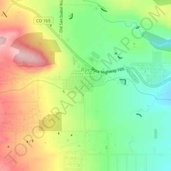
Nom : Carte topographique Rye, altitude, relief.
Lieu : Rye, Pueblo County, Colorado, United States (37.91799 -104.93739 37.92419 -104.92841)
Altitude moyenne : 2 090 m
Altitude minimum : 2 004 m
Altitude maximum : 2 199 m
Faire un don
Équipez-vous pour votre prochaine aventure :
En tant que Partenaire Amazon, ce site perçoit une commission sur les achats éligibles sans surcoût pour vous.
Autres cartes topographiques
Cliquez sur une carte pour visualiser sa topographie, son altitude et son relief.
Faire un don
Équipez-vous pour votre prochaine aventure :
En tant que Partenaire Amazon, ce site perçoit une commission sur les achats éligibles sans surcoût pour vous.