
Carte topographique Jaworze
Carte interactive
Cliquez sur la carte pour afficher l’altitude.
À propos de cette carte
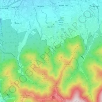
Nom : Carte topographique Jaworze, altitude, relief.
Altitude moyenne : 522 m
Altitude minimum : 325 m
Altitude maximum : 1 032 m
The Polish name is of topographic origins and is derived from sycamore trees (Polish: jawor. German name is a composition of a personal name Ern(st) and dorf (German: a village).
Autres cartes topographiques
Cliquez sur une carte pour visualiser sa topographie, son altitude et son relief.
Czechowice-Dziedzice
Poland > Silesian Voivodeship > Bielsko County
Czechowice-Dziedzice, gmina Czechowice-Dziedzice, Bielsko County, Silesian Voivodeship, Poland
Altitude moyenne : 263 m
Bielsko-Biała
Poland > Silesian Voivodeship > Bielsko County
Bielsko-Biała, Bielsko County, Silesian Voivodeship, Poland
Altitude moyenne : 432 m
Szczyrk
Poland > Silesian Voivodeship > Bielsko County > Szczyrk
Szczyrk, Bielsko County, Silesian Voivodeship, 43-370, Poland
Altitude moyenne : 746 m