
Faire un don
Équipez-vous pour votre prochaine aventure :
En tant que Partenaire Amazon, ce site perçoit une commission sur les achats éligibles sans surcoût pour vous.
Carte topographique Valle de Bravo
Cliquez sur la carte pour afficher l’altitude.
Faire un don
Équipez-vous pour votre prochaine aventure :
En tant que Partenaire Amazon, ce site perçoit une commission sur les achats éligibles sans surcoût pour vous.
Valle de Bravo
The municipality is surrounded by mountain ranges and other elevated areas covering about 50% of the total area and include the Sierra de Temascaltepec, Sierra de Tenayac, Sierra de Valle de Bravos as wells as the hills that roll around the mountain ranges. These elevations include a number of small volcanoes such as the "Cerro Gordo". 30% of the area is semi-flat with only 20% of the surface being plains. The main river of the area is the Río Balsas, whose system includes the tributaries of El Salto, Barranca Honda, Tiloxtoc rivers.
Faire un don
Équipez-vous pour votre prochaine aventure :
En tant que Partenaire Amazon, ce site perçoit une commission sur les achats éligibles sans surcoût pour vous.
À propos de cette carte
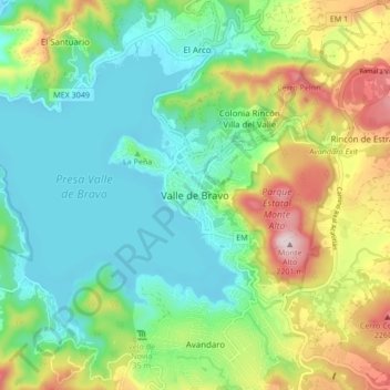
Nom : Carte topographique Valle de Bravo, altitude, relief.
Lieu : Valle de Bravo, State of Mexico, 51200, Mexico (19.15426 -100.17166 19.23426 -100.09166)
Altitude moyenne : 1 914 m
Altitude minimum : 1 773 m
Altitude maximum : 2 216 m
Faire un don
Équipez-vous pour votre prochaine aventure :
En tant que Partenaire Amazon, ce site perçoit une commission sur les achats éligibles sans surcoût pour vous.