
Faire un don
Équipez-vous pour votre prochaine aventure :
En tant que Partenaire Amazon, ce site perçoit une commission sur les achats éligibles sans surcoût pour vous.
Carte topographique Narni
Cliquez sur la carte pour afficher l’altitude.
Faire un don
Équipez-vous pour votre prochaine aventure :
En tant que Partenaire Amazon, ce site perçoit une commission sur les achats éligibles sans surcoût pour vous.
Narni
Narni (Latin: Narnia) is an ancient hilltown and comune of Umbria, in central Italy, with 19,252 inhabitants (2017). At an altitude of 240 metres (790 ft), it overhangs a narrow gorge of the Nera River in the province of Terni. It is very close to the geographic center of Italy. There is a stone on the exact spot with a sign in multiple languages.
Faire un don
Équipez-vous pour votre prochaine aventure :
En tant que Partenaire Amazon, ce site perçoit une commission sur les achats éligibles sans surcoût pour vous.
À propos de cette carte
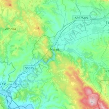
Nom : Carte topographique Narni, altitude, relief.
Lieu : Narni, Terni, Umbria, 05035, Italy (42.42158 12.41137 42.60082 12.61466)
Altitude moyenne : 250 m
Altitude minimum : 42 m
Altitude maximum : 1 017 m
Faire un don
Équipez-vous pour votre prochaine aventure :
En tant que Partenaire Amazon, ce site perçoit une commission sur les achats éligibles sans surcoût pour vous.
Autres cartes topographiques
Cliquez sur une carte pour visualiser sa topographie, son altitude et son relief.
Faire un don
Équipez-vous pour votre prochaine aventure :
En tant que Partenaire Amazon, ce site perçoit une commission sur les achats éligibles sans surcoût pour vous.