
Carte topographique Choczewo
Carte interactive
Cliquez sur la carte pour afficher l’altitude.
À propos de cette carte
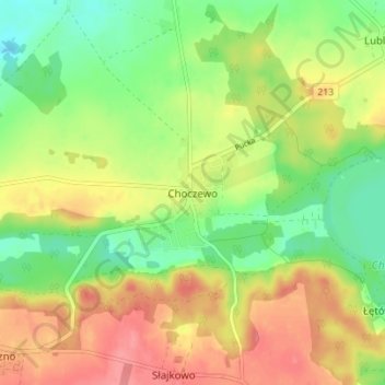
Nom : Carte topographique Choczewo, altitude, relief.
Altitude moyenne : 67 m
Altitude minimum : 32 m
Altitude maximum : 104 m
Autres cartes topographiques
Cliquez sur une carte pour visualiser sa topographie, son altitude et son relief.
Jezioro Żarnowieckie
Poland > Pomeranian Voivodeship > Wejherowo County > Czymanowo
Jezioro Żarnowieckie, Czymanowo, gmina Gniewino, Wejherowo County, Pomeranian Voivodeship, 84-250, Poland
Altitude moyenne : 37 m
Łęczyce
Poland > Pomeranian Voivodeship > Wejherowo County
Łęczyce, gmina Łęczyce, Wejherowo County, Pomeranian Voivodeship, Poland
Altitude moyenne : 52 m
Rumia
Poland > Pomeranian Voivodeship > Wejherowo County > Rumia
Rumia, Wejherowo County, Pomeranian Voivodeship, 84-230, Poland
Altitude moyenne : 69 m
Szemud
Poland > Pomeranian Voivodeship > Wejherowo County > Szemud
Szemud, gmina Szemud, Wejherowo County, Pomeranian Voivodeship, Poland
Altitude moyenne : 186 m
Reda
Poland > Pomeranian Voivodeship > Wejherowo County > Reda
Reda, Wejherowo County, Pomeranian Voivodeship, 84-240, Poland
Altitude moyenne : 57 m
Mierzyno
Poland > Pomeranian Voivodeship > Wejherowo County
Mierzyno, gmina Gniewino, Wejherowo County, Pomeranian Voivodeship, 84-250, Poland
Altitude moyenne : 70 m
Wejherowo
Poland > Pomeranian Voivodeship > Wejherowo County > Wejherowo
Wejherowo, Wejherowo County, Pomeranian Voivodeship, Poland
Altitude moyenne : 71 m