
Carte topographique Glen Arbor
Carte interactive
Cliquez sur la carte pour afficher l’altitude.
À propos de cette carte
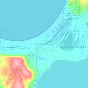
Nom : Carte topographique Glen Arbor, altitude, relief.
Altitude moyenne : 194 m
Altitude minimum : 172 m
Altitude maximum : 311 m
Autres cartes topographiques
Cliquez sur une carte pour visualiser sa topographie, son altitude et son relief.
Lake Leelanau
United States > Michigan > Leelanau County
Lake Leelanau, Leland Township, Leelanau County, Michigan, 49653, United States
Altitude moyenne : 210 m
Northport
United States > Michigan > Leelanau County
Northport, Leelanau Township, Leelanau County, Michigan, 49670, United States
Altitude moyenne : 193 m
Suttons Bay Township
United States > Michigan > Leelanau County
Suttons Bay Township, Leelanau County, Michigan, United States
Altitude moyenne : 221 m
Sleeping Bear Dunes National Lakeshore
United States > Michigan > Leelanau County
Sleeping Bear Dunes National Lakeshore, Leelanau County, Michigan, 49636, United States
Altitude moyenne : 204 m
Sleeping Bear Dunes
United States > Michigan > Leelanau County
Sleeping Bear Dunes, Glen Arbor Township, Leelanau County, Michigan, United States
Altitude moyenne : 231 m
Empire Township
United States > Michigan > Leelanau County
Empire Township, Leelanau County, Michigan, United States
Altitude moyenne : 244 m