
Carte topographique Zbory
Carte interactive
Cliquez sur la carte pour afficher l’altitude.
À propos de cette carte
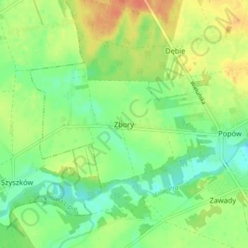
Nom : Carte topographique Zbory, altitude, relief.
Altitude moyenne : 212 m
Altitude minimum : 194 m
Altitude maximum : 233 m
Autres cartes topographiques
Cliquez sur une carte pour visualiser sa topographie, son altitude et son relief.
gmina Miedźno
Poland > Silesian Voivodeship > Kłobuck County
gmina Miedźno, Kłobuck County, Silesian Voivodeship, Poland
Altitude moyenne : 220 m
Przedmieście
Poland > Silesian Voivodeship > Kłobuck County > Zawady
Przedmieście, Zawady, gmina Popów, Kłobuck County, Silesian Voivodeship, 42-110, Poland
Altitude moyenne : 212 m
gmina Popów
Poland > Silesian Voivodeship > Kłobuck County
gmina Popów, Kłobuck County, Silesian Voivodeship, 42-110, Poland
Altitude moyenne : 212 m