
Carte topographique Manta
Carte interactive
Cliquez sur la carte pour afficher l’altitude.
À propos de cette carte
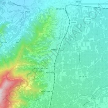
Nom : Carte topographique Manta, altitude, relief.
Lieu : Manta, Cuneo, Piedmont, Italy (44.60087 7.45223 44.62493 7.55684)
Altitude moyenne : 440 m
Altitude minimum : 298 m
Altitude maximum : 1 049 m
Autres cartes topographiques
Cliquez sur une carte pour visualiser sa topographie, son altitude et son relief.
Bersia
Italy > Piedmont > Cuneo > San Damiano Macra
Bersia, San Damiano Macra, Cuneo, Piedmont, 12020, Italy
Altitude moyenne : 1 336 m
Fre
Italy > Piedmont > Cuneo > Montemale di Cuneo
Fre, Montemale di Cuneo, Cuneo, Piedmont, Italy
Altitude moyenne : 997 m
Giardino Famiglia Allemandi
Italy > Piedmont > Cuneo > Villar San Costanzo > Pramallé
Giardino Famiglia Allemandi, Pramallé, Villar San Costanzo, Cuneo, Piedmont, Italy
Altitude moyenne : 654 m
Punta Razil
Italy > Piedmont > Cuneo > Bagnolo Piemonte
Punta Razil, Bagnolo Piemonte, Cuneo, Piedmont, Italy
Altitude moyenne : 2 008 m
Pontechianale
Pontechianale, Cuneo, Piedmont, Italy
Altitude moyenne : 2 447 m
Limone Piemonte
Limone Piemonte, Cuneo, Piedmont, 12015, Italy
Altitude moyenne : 1 619 m