
Carte topographique Lecco
Carte interactive
Cliquez sur la carte pour afficher l’altitude.
Lecco
The territory has a very variable altimeter distribution: it ranges from 198 meters above sea level in the lake area to the maximum altitude of 1875 meters above the sea level of Mount Resegone and this condition offers the city three different areas characterized by different morphologic and climatic characteristics.
À propos de cette carte
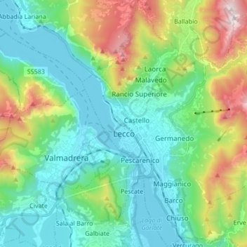
Nom : Carte topographique Lecco, altitude, relief.
Lieu : Lecco, Lombardy, 23900, Italy (45.81219 9.36677 45.90614 9.48490)
Altitude moyenne : 575 m
Altitude minimum : 193 m
Altitude maximum : 1 647 m