
Carte topographique Athlone
Carte interactive
Cliquez sur la carte pour afficher l’altitude.
À propos de cette carte
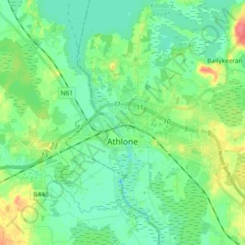
Nom : Carte topographique Athlone, altitude, relief.
Lieu : Athlone, County Westmeath, Leinster, Ireland (53.40664 -8.01690 53.45088 -7.88754)
Altitude moyenne : 43 m
Altitude minimum : 28 m
Altitude maximum : 81 m
Autres cartes topographiques
Cliquez sur une carte pour visualiser sa topographie, son altitude et son relief.
Torque
Torque, Newtown ED, The Municipal District of Athlone — Moate, County Westmeath, Leinster, Ireland
Altitude moyenne : 92 m
Abbeyland and Charlestown or Ballynamonaster
Abbeyland and Charlestown or Ballynamonaster, Kilbixy ED, The Municipal District of Athlone — Moate, County Westmeath, Leinster, Ireland
Altitude moyenne : 65 m
Meehan
Meehan, Moydrum ED, The Municipal District of Athlone — Moate, County Westmeath, Leinster, Ireland
Altitude moyenne : 40 m
Ballymore
Ireland > County Westmeath > Ballymore
Ballymore, The Municipal District of Athlone — Moate, County Westmeath, Leinster, Ireland
Altitude moyenne : 83 m