
Carte topographique Nestani
Carte interactive
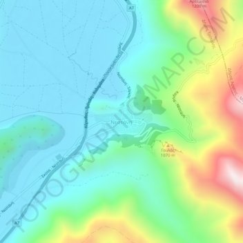
Cliquez sur la carte pour afficher l’altitude.
À propos de cette carte
Nom : Carte topographique Nestani, altitude, relief.
Altitude moyenne : 827 m
Altitude minimum : 623 m
Altitude maximum : 1 422 m
It is situated at the foot of the mountain Artemisio, at about 700 m elevation. It was the seat of the former municipality Mantineia. The community Nestani also contains the village of Milea. Nestani is 11 km east of Kapsas, 13 km southwest of Lyrkeia (Argolis) and 14 km northeast of Tripoli. The Moreas Motorway (Corinth–Tripoli-Kalamata/Sparta) passes west of the village.
Autres cartes topographiques
Cliquez sur une carte pour visualiser sa topographie, son altitude et son relief.
Tower of Nestani
Greece > Peloponnese, Western Greece and the Ionian > Arcadia Regional Unit > Municipal Unit of Mantineia
Tower of Nestani, Corinth - Tripoli - Kalamata, κ. Σάγκα, Community of Nestani, Municipal Unit of Mantineia, Municipality of Tripoli, Arcadia Regional Unit, Peloponnese Region, Peloponnese, Western Greece and the Ionian, 220 05, Greece
Altitude moyenne : 753 m