
Carte topographique Charlotte
Carte interactive
Cliquez sur la carte pour afficher l’altitude.
À propos de cette carte
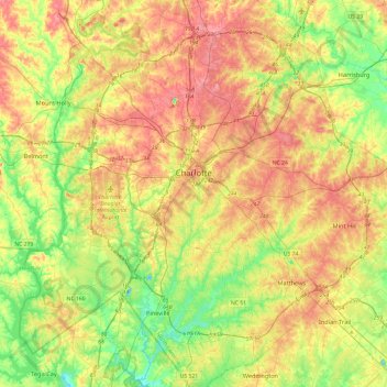
Nom : Carte topographique Charlotte, altitude, relief.
Lieu : Charlotte, Mecklenburg County, North Carolina, United States (35.01052 -81.00955 35.40025 -80.63488)
Altitude moyenne : 207 m
Altitude minimum : 152 m
Altitude maximum : 271 m
According to the United States Census Bureau, the city has a total area of 312.00 square miles (808.1 km2), of which 310.02 square miles (802.9 km2) is land and 1.98 square miles (5.1 km2) (0.63%) is water. Charlotte is the twenty-sixth-most expansive city in the United States and lies at an elevation of 751 feet (229 m). Charlotte constitutes most of Mecklenburg County in the Carolina Piedmont. Uptown Charlotte sits atop a long rise between two creeks, Sugar Creek and Irwin Creek, and was built on the gunnies of the St. Catherine's and Rudisill gold mines. Charlotte is 25 miles (40 km) southwest of Concord, 26 miles (42 km) northeast of Rock Hill, South Carolina, 83 miles (134 km) southwest of Greensboro, 135 miles (217 km) west of Fayetteville, and 165 miles (266 km) southwest of Raleigh, the state capital.
Autres cartes topographiques
Cliquez sur une carte pour visualiser sa topographie, son altitude et son relief.
Dixie
United States > North Carolina > Mecklenburg County
Dixie, Mecklenburg County, North Carolina, 29012, United States
Altitude moyenne : 198 m
Huntersville
United States > North Carolina > Mecklenburg County
Huntersville, Mecklenburg County, North Carolina, United States
Altitude moyenne : 226 m
Mayfair
United States > North Carolina > Mecklenburg County > Charlotte
Mayfair, Charlotte, Mecklenburg County, North Carolina, 28211, United States
Altitude moyenne : 212 m
Mint Hill
United States > North Carolina > Mecklenburg County
Mint Hill, Mecklenburg County, North Carolina, 28227, United States
Altitude moyenne : 218 m