
Carte topographique Pearl Island
Carte interactive
Cliquez sur la carte pour afficher l’altitude.
À propos de cette carte
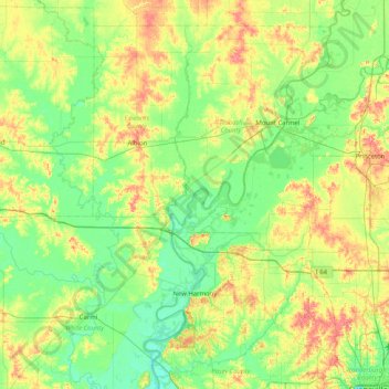
Nom : Carte topographique Pearl Island, altitude, relief.
Lieu : Pearl Island, Gibson County, Indiana, USA (37.97088 -88.25503 38.61088 -87.61503)
Altitude moyenne : 130 m
Altitude minimum : 105 m
Altitude maximum : 184 m
Autres cartes topographiques
Cliquez sur une carte pour visualiser sa topographie, son altitude et son relief.
Middle Fork of Wildcat Creek
Middle Fork of Wildcat Creek, Clinton County, Indiana, 46065, USA
Altitude moyenne : 215 m
Mount Etna
USA > Indiana > Mount Etna
Mount Etna, Huntington County, Indiana, USA
Altitude moyenne : 245 m