Géolocaliser

Carte topographique Kanyakumari

Cliquez sur la carte pour afficher l’altitude.

Kanyakumari

Kanniyakumari is located at 8°05′N 77°34′E / 8.08°N 77.57°E / 8.08; 77.57 and has an average elevation of 30 metres. The peninsular tip of Kanniyakumari is bordered on three sides by the Laccadive Sea. It is located at the confluence of the Western Coastal Plains and Eastern Coastal Plains. The nearest city is Thiruvananthapuram, Kerala (85 km (53 mi) away), and the nearest town is Nagercoil, the administrative headquarters of Kanniyakumari district (22 km (14 mi) away).

Wikipedia (CC-BY-SA 3.0)

À propos de cette carte

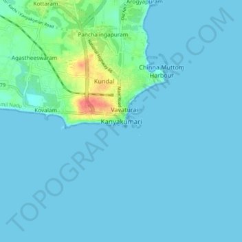
Nom : Carte topographique Kanyakumari, altitude, relief.

Lieu : Kanyakumari, Agastheeswaram, Kanniyakumari, Tamil Nadu, 629702, India (8.03925 77.50993 8.11925 77.58993)

Altitude moyenne : 6 m

Altitude minimum : 0 m

Altitude maximum : 55 m

Équipez-vous pour votre prochaine aventure :

🔥Réchauds de camping - Réchauds compacts pour cuisine outdoor
🧥Vestes de randonnée - Vestes respirantes et imperméables pour toutes saisons
🌧️Poncho de Pluie Respirant - Protection intégrale contre les intempéries en montagne
🧢Casquette avec Protège-Nuque - Protection solaire optimale pour les terrains découverts
🛰️GPS de Randonnée Portable - Appareil de navigation satellite robuste avec cartes préchargées

En tant que Partenaire Amazon, ce site perçoit une commission sur les achats éligibles sans surcoût pour vous.