
Carte topographique Torrance County
Carte interactive
Cliquez sur la carte pour afficher l’altitude.
À propos de cette carte
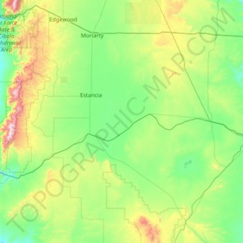
Nom : Carte topographique Torrance County, altitude, relief.
Lieu : Torrance County, New Mexico, United States (34.25968 -106.47122 35.04214 -105.29014)
Altitude moyenne : 1 983 m
Altitude minimum : 1 725 m
Altitude maximum : 3 035 m
According to the U.S. Census Bureau, the county has a total area of 3,346 square miles (8,670 km2), of which 0.9 square miles (2.3 km2) (0.03%) is covered by water. Most of the county is gently rolling grassland ranging from 6000 to 6200 feet in elevation. The Manzano Mountains rising to 10,098 feet on the western edge of the county provide it with its only significant topographic relief. The Manzano Wilderness area includes the highest part of the mountains. The other notable geographic feature of the county is the series of playas and seasonal lakes centering on Laguna del Perro southeast of Estancia.
Autres cartes topographiques
Cliquez sur une carte pour visualiser sa topographie, son altitude et son relief.
Santa Ana Pueblo
United States > New Mexico > Sandoval County
Santa Ana Pueblo, Sandoval County, New Mexico, United States
Altitude moyenne : 1 576 m
San Francisco
United States > New Mexico > Catron County
San Francisco, Catron County, New Mexico, United States
Altitude moyenne : 2 440 m
White Sands
United States > New Mexico > Doña Ana County
White Sands, Doña Ana County, New Mexico, 88002, United States
Altitude moyenne : 1 333 m
Santa Fe
United States > New Mexico > Santa Fe County
Santa Fe, Santa Fe County, New Mexico, United States
Altitude moyenne : 2 221 m
Catron County
Catron County, New Mexico, United States
Altitude moyenne : 2 231 m
Roswell
United States > New Mexico > Chaves County
Roswell, Chaves County, New Mexico, United States
Altitude moyenne : 1 106 m
Grant County
Grant County, New Mexico, United States
Altitude moyenne : 1 599 m
Riley Black Standpipe, Mount
United States > New Mexico > Doña Ana County
Riley Black Standpipe, Mount, Doña Ana County, New Mexico, United States
Altitude moyenne : 1 254 m
Standing Rock
United States > New Mexico > McKinley County > Standing Rock
Standing Rock, Eastern Navajo Agency, McKinley County, New Mexico, United States
Altitude moyenne : 1 931 m
Chama
United States > New Mexico > Rio Arriba County > Chama
Chama, Rio Arriba County, New Mexico, 87520, United States
Altitude moyenne : 2 430 m
Mount Taylor
United States > New Mexico > Cibola County
Mount Taylor, Cibola County, New Mexico, United States
Altitude moyenne : 3 168 m
Torreon
United States > New Mexico > Sandoval County
Torreon, Eastern Navajo Agency, Sandoval County, New Mexico, United States
Altitude moyenne : 1 984 m
Tinian
United States > New Mexico > McKinley County > Tinian
Tinian, McKinley County, New Mexico, United States
Altitude moyenne : 2 014 m
Rancho Viejo
United States > New Mexico > Rancho Viejo
Rancho Viejo, Santa Fe County, New Mexico, 87507-9720, United States
Altitude moyenne : 1 979 m
Mora County
Mora County, New Mexico, United States
Altitude moyenne : 2 150 m
Cibola County
Cibola County, New Mexico, United States
Altitude moyenne : 2 124 m
Taos County
Taos County, New Mexico, United States
Altitude moyenne : 2 561 m
Socorro County
Socorro County, New Mexico, United States
Altitude moyenne : 1 830 m
Santa Fe County
Santa Fe County, New Mexico, United States
Altitude moyenne : 2 177 m
Bernalillo County
Bernalillo County, New Mexico, United States
Altitude moyenne : 1 808 m
Lea County
United States > New Mexico > Lea County
Lea County, New Mexico, United States
Altitude moyenne : 1 100 m
Shiprock
United States > New Mexico > San Juan County
Shiprock, Shiprock Agency, San Juan County, New Mexico, 87420, United States
Altitude moyenne : 1 524 m
Angel Fire
United States > New Mexico > Colfax County
Angel Fire, Colfax County, New Mexico, 87710, United States
Altitude moyenne : 2 786 m