
Carte topographique Gorontalo
Carte interactive
Cliquez sur la carte pour afficher l’altitude.
Gorontalo
Topographically, the province is relatively low (0–40o), with the elevation ranging between 0–2,400 m (7,900 ft) above sea level. Its coastline length is more than 590 km (370 mi). Counting the Exclusive Economic Zone to the north where Philippines is at the border, the total sea area of the province is more than 50,500 km2 (19,500 sq mi). There are some small islands around the north and the south of the province, 67 of which have been identified and named.
À propos de cette carte
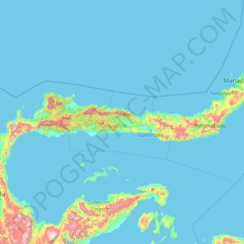
Nom : Carte topographique Gorontalo, altitude, relief.
Lieu : Gorontalo, Indonesia (-1.84138 119.89559 3.27862 125.01559)
Altitude moyenne : 123 m
Altitude minimum : -1 m
Altitude maximum : 2 641 m