
Carte topographique Castle Rock
Carte interactive
Cliquez sur la carte pour afficher l’altitude.
À propos de cette carte
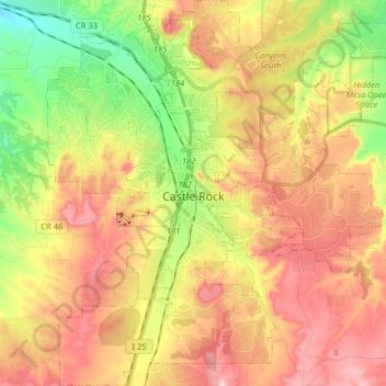
Nom : Carte topographique Castle Rock, altitude, relief.
Lieu : Castle Rock, Douglas County, Colorado, United States (39.31127 -104.91980 39.43495 -104.76128)
Altitude moyenne : 1 952 m
Altitude minimum : 1 783 m
Altitude maximum : 2 116 m
Castle Rock is located at 39°22′20″N 104°51′22″W / 39.37222°N 104.85611°W / 39.37222; -104.85611 (39.372212, −104.856090) at an elevation of 6,224 feet (1,897 m). Castle Rock is in central Colorado at the junction of Interstate 25 and State Highway 86, 28 mi (45 km) south of downtown Denver and 37 mi (60 km) north of Colorado Springs.