
Carte topographique Cox's Bazar
Carte interactive
Cliquez sur la carte pour afficher l’altitude.
Cox's Bazar
Cox's Bazar lies on a coastal plain in the southeastern corner of Bangladesh. From above, the plain appears to bulge out into the Bay of Bengal. Along the shore is an extensive area of beach and dunes. Most of the city is built on a floodplain that is lower in elevation than the dunes, making it more susceptible to flooding due to cyclones and storm surges. The Cox's Bazar coastal plain was formed after the sea reached its present level around 6,500 years ago, with the area of the current floodplain originally forming a sediment sink that has since been gradually filled in by the Bakkhali river as well as smaller streams coming down from the hills.
À propos de cette carte
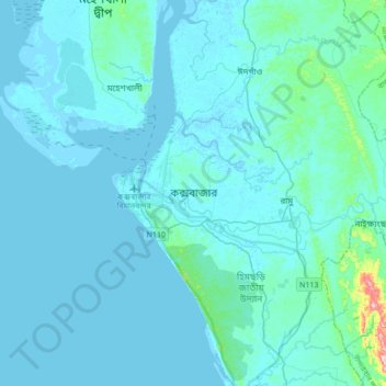
Nom : Carte topographique Cox's Bazar, altitude, relief.
Altitude moyenne : 13 m
Altitude minimum : -4 m
Altitude maximum : 223 m