
Carte topographique San Nicolás (Municipio)
Carte interactive
Cliquez sur la carte pour afficher l’altitude.
À propos de cette carte
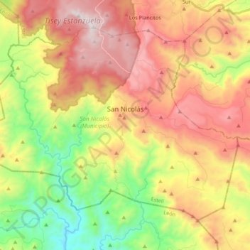
Nom : Carte topographique San Nicolás (Municipio), altitude, relief.
Lieu : San Nicolás (Municipio), Estelí, 32400, Nicaragua (12.85957 -86.43840 12.98497 -86.27491)
Altitude moyenne : 868 m
Altitude minimum : 217 m
Altitude maximum : 1 558 m
Autres cartes topographiques
Cliquez sur une carte pour visualiser sa topographie, son altitude et son relief.
Comunidad La Garnacha
Nicaragua > Estelí > San Nicolás (Municipio)
Comunidad La Garnacha, San Nicolás (Municipio), Estelí, 32400, Nicaragua
Altitude moyenne : 1 294 m
Cerro El Tisey
Nicaragua > Estelí > San Nicolás (Municipio)
Cerro El Tisey, San Nicolás (Municipio), Estelí, 32400, Nicaragua
Altitude moyenne : 1 384 m
Comunidad La Garnacha
Nicaragua > Estelí > San Nicolás (Municipio) > Comunidad La Garnacha
Comunidad La Garnacha, San Nicolás (Municipio), Estelí, 32400, Nicaragua
Altitude moyenne : 1 249 m