
Faire un don
Équipez-vous pour votre prochaine aventure :
En tant que Partenaire Amazon, ce site perçoit une commission sur les achats éligibles sans surcoût pour vous.
Carte topographique Cumberland Shores
Cliquez sur la carte pour afficher l’altitude.
Faire un don
Équipez-vous pour votre prochaine aventure :
En tant que Partenaire Amazon, ce site perçoit une commission sur les achats éligibles sans surcoût pour vous.
À propos de cette carte
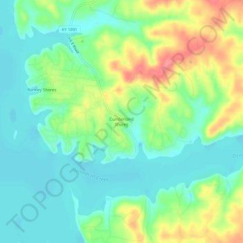
Nom : Carte topographique Cumberland Shores, altitude, relief.
Lieu : Cumberland Shores, Trigg County, Kentucky, United States (36.73227 -87.96780 36.77227 -87.92780)
Altitude moyenne : 131 m
Altitude minimum : 104 m
Altitude maximum : 181 m
Faire un don
Équipez-vous pour votre prochaine aventure :
En tant que Partenaire Amazon, ce site perçoit une commission sur les achats éligibles sans surcoût pour vous.
Autres cartes topographiques
Cliquez sur une carte pour visualiser sa topographie, son altitude et son relief.
Land Between the Lakes National Recreation Area
United States > Kentucky > Trigg County
The United States Army Corps of Engineers constructed a dam on the Cumberland, producing another lake. It was planned to be at the same elevation as Kentucky Lake, and the two rivers were to be connected by a canal that did not require locks. This project was intended to lessen the shipping distances for goods…
Altitude moyenne : 146 m