
Carte topographique Greenville County
Carte interactive
Cliquez sur la carte pour afficher l’altitude.
À propos de cette carte
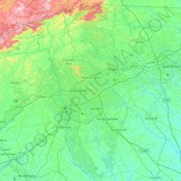
Nom : Carte topographique Greenville County, altitude, relief.
Lieu : Greenville County, South Carolina, USA (34.48406 -82.76441 35.21549 -82.14696)
Altitude moyenne : 308 m
Altitude minimum : 135 m
Altitude maximum : 1 130 m
Autres cartes topographiques
Cliquez sur une carte pour visualiser sa topographie, son altitude et son relief.
Kiawah Island
USA > South Carolina > Kiawah Island
Kiawah Island, Charleston County, South Carolina, USA
Altitude moyenne : 2 m
Red Hill
USA > South Carolina > Red Hill
Red Hill, Horry County, South Carolina, USA
Altitude moyenne : 9 m
Hilton Head Island
USA > South Carolina > Hilton Head Island
Hilton Head Island, Beaufort County, South Carolina, USA
Altitude moyenne : 2 m
Abbeville
USA > South Carolina > Abbeville
Abbeville, Abbeville County, South Carolina, USA
Altitude moyenne : 174 m
Simmonsville
USA > South Carolina > Simmonsville
Simmonsville, Georgetown County, South Carolina, USA
Altitude moyenne : 5 m
Tenmile
USA > South Carolina > Tenmile
Tenmile, Charleston County, South Carolina, 29416, USA
Altitude moyenne : 9 m
Pine Creek
USA > South Carolina > Pine Creek
Pine Creek, Kershaw County, South Carolina, 29020, USA
Altitude moyenne : 73 m
Cape Romain National Wildlife Refuge
USA > South Carolina > Awendaw
Cape Romain National Wildlife Refuge, Awendaw, Charleston County, South Carolina, USA
Altitude moyenne : 3 m