
Carte topographique Elizaville
Carte interactive
Cliquez sur la carte pour afficher l’altitude.
À propos de cette carte
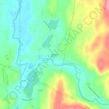
Nom : Carte topographique Elizaville, altitude, relief.
Altitude moyenne : 105 m
Altitude minimum : 58 m
Altitude maximum : 195 m
Autres cartes topographiques
Cliquez sur une carte pour visualiser sa topographie, son altitude et son relief.
Blue Stores
United States > New York > Columbia County > Town of Livingston
Blue Stores, Town of Livingston, Columbia County, New York, 12526, United States
Altitude moyenne : 63 m
Burden
United States > New York > Columbia County > Town of Livingston
Burden, Town of Livingston, Columbia County, New York, United States
Altitude moyenne : 60 m
Linlithgo Mills
United States > New York > Columbia County > Town of Livingston
Linlithgo Mills, Town of Livingston, Columbia County, New York, 12541, United States
Altitude moyenne : 76 m
Linlithgo
United States > New York > Columbia County > Town of Livingston
Linlithgo, Town of Livingston, Columbia County, New York, United States
Altitude moyenne : 49 m